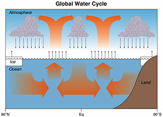
Water continually cycles among land, ocean, and
atmosphere via transpiration, evaporation, condensation
and crystallization, and precipitation, as well as downhill
flows on land.
A portion of his webinar talk about the connections between ocean salinity, the water cycle, and global climate, Dr. Ray Schmitt talks about how conventional water cycle diagrams need a larger focus on the ocean.
Slideshow of Resources
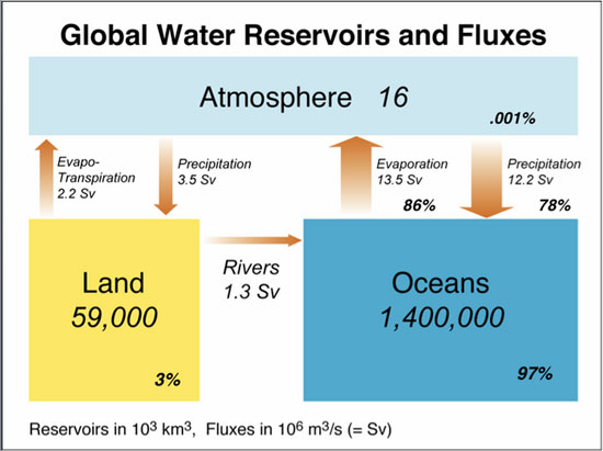
Images used by Dr. Schmitt during his webinar include: 1) concept map overview, 2) a diagram depicting global water fluxes, 3) a graph showing net water transport from the Northern Hemisphere to the South, and 4) a Seaglider, an example of the technology used to collect data that better informs water cycle modeling.
Applicable Performance Standards
MS-ESS2-4
Collect data to provide evidence for how the motions and complex interactions of air masses results in changes in weather conditions.
This material is based upon work supported by the National Science Foundation (NSF) under Grant # NSF OCE-0707385. Any opinions, findings, and conclusions or recommendations expressed in this material are those of the author(s) and do not necessarily reflect the views of the NSF.
COSEE-Ocean Systems Central Office School of Marine Sciences, University of Maine Darling Marine Center 193 Clark's Cove Road Walpole, ME 04573
Phone: (207) 563-8176 E-mail: cosee-os