Most people understand that significant climate changes are predicted in the next century, but they may not be aware that these changes will likely vary regionally. Using climatological data from the University of New Hampshire's EOS-Webster, students will obtain annual predictions for minimum temperature, maximum temperature, precipitation, and solar radiation for Minnesota and California to explore this regional variability. They will learn how to access climate model predictions from EOS-Webster, a digital library of free Earth science data. They will then be walked through the process step-by-step of producing graphs of the data in a spreadsheet application to compare climate predictions among U.S. states through the year 2100. Students are asked to analyze the graphs to interpret regional trends in climate change. Data used: Climate Model Predictions. Tools used: EOS-Webster, and access to the a spreadsheet application like Microsoft Excel.
This Webcast is an expert lecture by Dr. Kevin Trenberth of NCAR's Climate and Global Dynamics division published on June 14, 2004. The presentation includes evidence that the atmosphere is changing, discussions on global energy flows and human factors contributing to change, and concludes with predictions for the future.
This report describes the results of a study in which climate modeling was used to examine the effects of deforestation in the Amazon basin. The study concluded that changes in land surface properties (loss of forest cover) cause changes in the mean surface wind stress in the tropical Pacific, which in turn results in increased variability of El Nino/Southern Oscillation (ENSO) events.
This animated lesson focuses on ocean currents. Some of the topics covered include: gravity- and wind-driven currents, the Coriolis Effect, El Nino, longshore currents, upwelling, and the global conveyor belt. Additional links to the global impact of ocean currents (video), El Nino (activity), and currents and marine life (activity) are available.
This hands-on Oceanography article describes an activity that helps students better understand the nonintuitive concept of diffusion and introduces them to a variety of diffusion-related processes in the ocean. As part of this activity, students also practice data collection and statistical analysis (e.g., average, variance, and probability distribution functions).
Interactive maps of surface conditions can be clicked on this tool to create in-water profiles of salinity, temperature, or density. Sources include interpolated atlas data or actual measurements from the database.
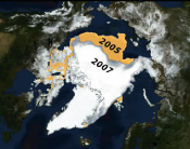
How can we use ice core data from the polar regions to investigate changes in Earth's climate past, present, and future? Students investigate climate changes going back thousands of years by graphing and analyzing ice core data from Greenland and Antarctica.
Students will use a lab activity to describe the change in water level when the water is exposed to heat, differentiate between thermal expansion and melting snow and ice fields as they relate to sea level rise, and predict the impact of rising sea level on coastal areas.
Students observe convection in water due to temperature differences and describe the pattern of water movement with words and pictures. During a class discussion students learn that the same process happens in both the oceans and the atmosphere.
This multimedia CD-ROM provides a virtual microscope, build your own phytoplankton bloom, special topics such as upwelling, and background information in the study of primary productivity and phytoplankton in our oceans.
This material is based upon work supported by the National Science Foundation (NSF) under Grant # NSF OCE-0707385. Any opinions, findings, and conclusions or recommendations expressed in this material are those of the author(s) and do not necessarily reflect the views of the NSF.
COSEE-Ocean Systems Central Office School of Marine Sciences, University of Maine Darling Marine Center 193 Clark's Cove Road Walpole, ME 04573
Phone: (207) 563-8176 E-mail: cosee-os