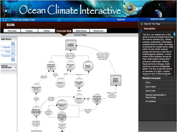
Concept maps show how the major concepts (square or rectangle icons) and subconcepts (circle icons) are connected. In the example at right, you entered the map through the "Sun" concept. Rolling your mouse over the icons will display how many assets are associated with each concept or subconcept (roll your mouse over the "Day & night length" circle (located about center in the image at right) to see that there are 10 videos, 11 images, 7 news articles, and 9 resources associated with this subconcept (click here for a closeup view). Clicking on the icons will take you to the asset galleries. Related concepts are also listed in the right sidebar and clicking on a topic here will also take you to the asset galleries (roll your mouse over "Day & night"). At right, roll over "Map Scale" in the left margin to zoom in / out. On the Ocean Climate Interactive (OCI), up to twelve zoom levels are available. On the OCI, you can also click on the white space in the map with your left mouse button to move the map around. At right, roll over the "N.S.E.S. Color Key" in the left margin to see the color-coding scheme that aligns with the National Science Education Standards. On the OCI website, you can see brief descriptions for these standards. You can also turn the color key ON or OFF for ALL or individual standards. Previous | Next | Index | |||||||
)