|
How Do Scientists Collect Measurements at Different Depths?
Moorings are stationary platforms
that can carry multiple instruments to collect data both above and below the ocean surface. One of the major goals of SPURS is to
deploy an array of three oceanographic moorings; a single Woods Hole Oceanographic Institution (WHOI)
surface flux mooring and two Pacific Marine Environmental Laboratory (PMEL) Prawler moorings.
These moorings will be deployed for one year, collecting information on the central part of the study area.Each mooring is made up of two parts: a surface buoy and a subsurface mooring wire. The surface buoy measures meteorological parameters like wind speed, solar radiation, and humidity, which indicate how the ocean is interacting with the atmosphere. Multiple instruments are attached to the subsurface mooring wire for collection of data throughout the water column. Visit WHOI for videos and interactive multimedia on moorings and buoys. Featured Video: Why the Top Centimeter Matters
Types of Stationary Platforms
(Click images for enlarged views)
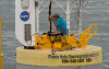
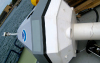
What does it do? Surface flux moorings collect surface measurements of atmospheric parameters, radiation, turbulence, evaporation, waves, and precipitation and subsurface measurements of current direction and speed, temperature, and salinity. How does it work? The surface buoy is made up of an Air-Sea Interaction METeorology (ASIMET) System, consisting of seven sensors that measure how energy and water move between the ocean and atmosphere (read more about the ASIMET System here). The ASIMET system sits in a large foam float, which is attached to the subsurface mooring line. The subsurface mooring line has multiple instruments attached to take measurements down to 500m below the surface.
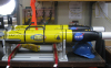
What does it do? A Prawler mooring obtains a vertical profile of conductivity, temperature, and depth using a single sensor. How does it work? The Prawler part of the mooring is a single, subsea instrument that uses wave-powered technology to move up and down a mooring line. After the Prawler reaches its pre-programmed bottom depth, a ratcheting mechanism harnesses the wave motion to crawl up the mooring line to the top before starting the process over again. Click here for a schematic of the Prawler mooring and instrument. |

)
 is about the size of a paint can. Using only energy from the waves, the ratchet tightens and releases its way back up the mooring line in order to take another CTD profile.','Prawler mooring'))
)
, which sits in a large foam float attached to a subsurface mooring line','ASIMET system'))
 attached to a subsurface mooring line','Foat float'))
)
| |
This material is based upon work supported by NASA under NASA Jet Propulsion Laboratory Subcontract No. 1459277. Any opinions,
findings, and conclusions or recommendations expressed in this material are those of the author(s) and do not necessarily
reflect the views of NASA. SPURS Education & Outreach Office School of Marine Sciences, University of Maine Darling Marine Center | 193 Clark's Cove Road | Walpole, Maine 04573 Phone: (207) 563-8176 | Email |