| Important links: | Directions to UConn Campus | Directions to Hotel Hotel Info | Scientist Bios |
We hear you loud & clear!
A goal that is very important for us is to take in feedback and suggestions to continuously make improvements in the way that we operate and the tools that we develop. As you read in the previous post, we're constantly getting feedback from our workshops, and we really do take it to heart. From the surveys that we gave the workshop participants, there are several things that were mentioned often as suggestions for changes. Below are a few responses, and what we plan to do about it!
"I wanted more focus on forming lasting collaborations with scientists."
We heard this in a few different forms - the educators in this workshop hungered for more interactions with scientists, and we've been thinking about this a long time. One of our solutions is that we are developing on-line workshops to try and continue or develop scientist/educator interactions further than the three day workshop, too. Also, our new Marine Education Associate, Medea Steinman, is going to continue working with educators from past workshops to continue to support them in their own classrooms – and part of that may be through scientist collaboration as well. "It would be nice if there were more local (Long Island Sound) resources and assets."
In the Ocean Climate Interactive, we've compiled a big database of vetted resources that are free to use educationally. Because it is used nation-wide, we have so far stayed away from adding lots of local-specific resources, so this is a valid observation about what's in our database. However, we are in the process of implementing ways that certain organizations or people could become resource "ambassadors" that would be given permissions to upload assets of their choosing. So, for example, an organization like Connecticut Sea Grant could get permission to upload some of the resources that are more LIS specific for educators in the CT/NY area to access. We'll keep you all posted on how that goes as we develop it - great idea! "How can I match state learning standards with the concepts in the OCI?"
At this time, it's beyond the scope of COSEE-OS to offer this for each state. However, the concepts in the Ocean Climate Interactive are based on Ocean and Climate Literacy Principles. The Ocean and Climate Literacy brochures include matrices tying each principle to the National Science Education Standards, which educators can use to make linkages to their own state standards. They're available in pdf form below. If you prefer hard copies, send us an email and we'll get some out to you!- Ocean Literacy Brochure (PDF 3.85 MB)
- Climate Literacy Brochure (PDF 4.77 MB)
- Ocean Literacy Matrix (PDF 536 KB)
- Climate Literacy Matrix (PDF 161 KB)
"Its difficult to present the concept map in the OCI because the screen area seems small."
Fear not, we're tackling this one as we speak! Our programmers are re-working the concept map viewing part of the website so that it takes advantage of the whole window, and is easier to navigate. I'll write a full post soon about the changes in the next release of the software, so stay tuned! "I am afraid I'll fall out of touch with the great people I met during the workshop. Can you make a listserv so that it'll be easy for us to keep up?"
Great suggestion! We're in the process of creating one now. Participants will get an email soon with details asking them if they'd like to join. We know that the relationships that educators and scientists form with each other (as well as their colleagues) are something that's important about the workshop experience. We also want to let the whole group know what everyone is doing after the workshop. To do this we've created the workshop page for the COSEE website, and we'll continue to post case-studies, follow-ups and other stories from the workshop on our site, and we'll send out notifications for future collaborative opportunities as well. POSTED BY COSEE-OS AT 2:18 PM
"Oh, the places you'll go"
On the third day of the workshop, educators were split into different groups in order to generate ideas on how concept mapping could be useful to them in their home schools or institutions. Three groups (about five in each group) were broken out - a "middle school" teachers (formal educators) group, a "high school" teachers (formal educators) group and finally an "informal" educators group. Each different group generated a list of possible uses - and many we had never heard before.
Middle School
- Could be used as a tutorial for students who were absent from school.
- Many schools use websites to post materials for absent students, could link to concept map.
- As a presentation or in-service guide - note taking training.
- Students could use it to create a concept map to lead a class discussion about concepts taught.
- It could be used for review or assessment.
- It could be adapted to help students learn word stems, science vocabulary or to connect to the correct word as it is used in a sentence.
- It could also be used for students who are seeking enrichment (TAG).
- It could be a vehicle for note taking during lectures.
- Students could fill in concept maps from broad concept map given by teacher to narrow down what they had learned.
- Cycle assessments.
- Teaching the Scientific Method.
- The concept map could be spread out onto the floor for a collaborative activity.
- It could be used to share with teaching colleagues (like a lesson plan) and have colleagues fill in their own notes - use their thoughts to enhance the teaching of the lesson.
- Could use the Ocean Climate Interactive assets in presentations.
- Helpful for note-taking - students have a copy of the complete map, teacher then shows small parts of the map on the large screen.
- Making maps with students - working in a computer lab, show an example, then outline the current topics.
- Evolution topics - list of vocabulary, make a concept map - make the assignment public.
- POP (Persistent Organic Pollutants) pass the scientific pollution agent through the map and chart and determine the movement through the system.
- Use the introduced species map to track a new example through the system.
- Inquiry topics - webbing is more like random thinking/multiple intelligences.
- Planning tool w/links to initiation videos.
- Bring maps to community or town meetings ("can't drag everyone outside").
- Use for teacher training.
- Content source for grant training.
- Tool for teachers in classrooms.
- Use as a program assessment internally.
- Create overview for teachers that puts program topics in context while matching specifics of program.
- Create materials for teacher training.
- Use as a summary for scientific review of basic program concepts.
- Use framework to create background information, source for preparing information for writing.
- Set up maps to use as presentation tool for community leaders and decision makers to make informed decisions.
POSTED BY COSEE-OS AT 9:41 AM
We live for feedback!
Getting feedback is a key part of what keeps us running at COSEE-Ocean Systems. We collect data about the workshop and our tools to help us make each workshop we run a bit stronger than the last. For the UConn workshop, we were delighted to see the positive and enthusiastic response from educators. It's gratifying to know that they came away with resources they felt they could use in their own work - in their classrooms or informal institutions. Below are some of the highlights from the survey results.
Workshop in General
At least 80% of participants, often 90% or more, responded positively to questions about:
- How well their expectations were met by the workshop.
- The length and pacing of the workshop.
- The workshop experience overall (new learning and content, enjoyment, interactions with colleagues, scientists and COSEE-OS staff).
We use two of our online tools in each workshop, and we're always developing in response to participant feedback. For this workshop, the reactions were very positive. Everyone seemed to feel that both tools would be helpful in communicating ocean-climate concepts to audiences and in creating good lessons and presentations. Over 90% of educators felt concept mapping had been helpful in communicating ideas with scientists. Some participants weren't as sure that the OCI and CMB would be helpful in finding good education resources about some ocean and climate concepts in their curriculum. In response, we will continue to develop the tools to meet the needs of more users.
Ocean and Climate Literacy
For each of the 8 literacy concepts that this workshop centered around, everyone said that their comfort and sense of their relevance had either remained the same or increased. The degree to which this was the case varied between concepts. We'll have more detailed data available soon on the workshop's new evaluation page (coming soon!).
Interactions with Scientists
Respondents to our survey felt that the interactions with scientists were both positive and collegial. A few people felt that there was not enough interaction, and wished they could spend a lot of time working with educators in the future! A few wished they'd been able to spend more time learning more from the scientists about the content, or wished there had been more guidance about establishing collaborative relationships with the scientists after the workshop ends. A number of people said they would like to come back and do a repeat of the same workshop to follow-up with these colleagues and scientists and to learn more about the online tools as they develop. We are developing ways to continue these relationships outside the workshop - possible through online interactions - in the future.
POSTED BY COSEE-OS AT 12:59 AM
Workshop summary - part two!
The second day found us with a very busy room full of eager educators and scientists. After working (in some cases late into the evening) on their maps at home, the scientists were prepared to present and did a wonderful job. On the workshop page that we're creating for this workshop, there will be videos of their initial presentations for you to check out.
After that, it was into small teams to get down to the business of revising the original concept maps. One informal and two formal educators were paired in each group with a scientist, making the groups small but diverse in their makeup. Remember the post about matchmaking? The teams were created through a special COSEE-OS process to make sure that everyone would get a lot out of the interactions.
The room quickly filled with the din of collaborative conversation and even some laughter. Throughout the day, everyone got to get introduced to the Ocean Climate Interactive and Concept Map Builder, and lots of great ideas flew around. For those who completed the on-line tutorials, a game of COSEE Jeopardy was a piece of cake!
At the end of the long day, the educator groups presented their collective changes, and discussed what the process was like for them and what it was like to work with their scientists. The presentations were met with a lot of questions and suggestions for how the information could be used in a classroom or a program. These presentations can also be seen on the workshop pages that are being worked on right now.
Though the room felt small with so many folks in it, the view was beautiful and spirits seemed high. Many educators went out to dinner together at the Seamen's Inne in Mystic - to learn even more about their colleagues and their experience. The food was great - and, thankfully, most of us even got a full night's sleep after a happy meal (unlike the night before.)
POSTED BY COSEE-OS AT 11:04 AM
Workshop summary - part one!
I wanted to take a moment to thank our wonderful participants and scientists for making this workshop a success. The concept maps that were created in the scientist/educator teams were great, and the suggestisons and collaborative ideas were enlightening!
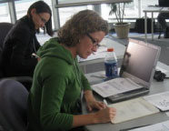 |
After a warm up activity they began to make their first concept maps, and talk aout their work (that they're quite passionate about). A little feedback from their colleagues and they were on their way to make the maps for the educators to see the next morning. By the end of the day the scientists seemed to be happy in each other's company - and eager to meet the educators the next day.
 |
Stay tuned - the recap part deux will continue tomorrow!
POSTED BY COSEE-OS AT 5:55 PM


