|
|
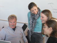
| SEARCH | FACULTY/GRADUATE STUDENT COLLABORATIVE WORKSHOPS | ||||||||||||||||||||||||||||||||||||||||||||||||||||||||||||||||||||||||||||||||||||||||||||||||||||||||||||||||||||||||||||||||||||||||||||||||||||||||||||||||||||||||||||||||||||||||||||||||||||||||||||||||||||||||||||||||||||||||||||||||||||||
|
Each team creates a pair of concept maps consisting of the following:
View All Public Maps on the COSEE-OS Concept Linked Integrated Map Builder here. Topic: Climate Change
(Click images to view and save maps)
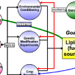
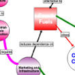
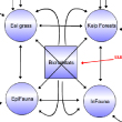
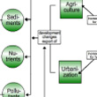
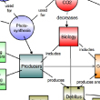
Biofuels, Crops & Climate Change
Given that the world will run out of cheap fuel within 20 years, how do we find another source to power our economy? This pair of maps
answers this hypothetical question with ideas such as using lipids (captured through culturing and processing of algae) as a fuel source.
The consensus map, intended for a public radio audience, brings scientific ideas into the economy by including the concepts of creating
a "green economy" and how these new greener technologies could create jobs.
Debashish Bhattacharya | Rutgers Workshop
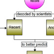
Climate Records at Different Time Scales
How can researchers look back on past climate trends and events if they happened thousands or millions of years ago? These two maps
address some of the ways that climate records are studied, including through ice cores, tree rings, microfossils and corals, and how
they are investigated and combined to produce climate records. The second map has been broken into two sections - what climate
influences, and what types of information can be gathered about climate from those records.
Arahdna Tripani | USC Workshop
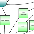
Impacts of Sea Level Change
Sea level change is not as straightforward as one would imagine. There are many factors that need to be taken into account to make
accurate predictions about what a warming climate will do to sea level. At the same time, the potential impacts of that rise need to
be anticipated by planners, stakeholders and other public officials. The original map combined these factors with references to several
new technologies that help bring this information together. The consensus map features a high-level view of the causes and impacts of
sea level change, with an emphasis on human and non-human coastal communities.
Neal Driscoll | Scripps Workshop
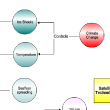
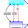
Oceans & Climate Change
The oceans are inexorably linked to climate, and both can be affected by climate change. In the scientist's original map, the focus is
on creating a clear set of relationships between the atmosphere, the open ocean, weather, circulation and climate change. The resulting
consensus map was scaled down to focus on ocean and atmosphere relationships with a greater emphasis on the exchange of heat in the
oceans and its role in regulating climate.
James Miller | Rutgers Workshop Topic: Cycling in Earth Systems
(Click images to view and save maps)
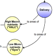
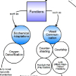
The Geochemical Cycle of Iron
There are many cycles in the ocean, and the movement of iron and other nutrients is one that involves not only organisms in the water,
but also geologic processes that uplift and expose sediments to the ocean floor. Depending on where these nutrients are "delivered," the
diversity of the phytoplankton can be changed. The graduate student team added background information on what geochemical cycles are, then
focused on the iron cycle as an example cycle.
Katherine Barbeau | Scripps Workshop
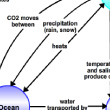
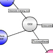
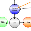
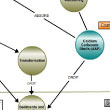
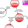
Is the Ocean Going to Solve our CO2 Problem?
The ocean absorbs carbon dioxide both by physical means and biological (via the biological pump and phytoplankton). This carbon dioxide
can dissolve or be sequestered deep in marine sediments, leading some to speculate that the ocean could help mitigate excess carbon dixoide
in the atmosphere. However, as revealed in the consensus map, the chemistry of the carbon and the means of its deposition are dependent
on many factors, and operate on longer time scales than may be useful for a "quick fix."
Elisabeth Sikes | Rutgers Workshop
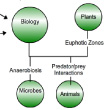
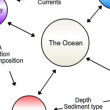
Is the Ocean the Same Everywhere?
It is easy to think of the ocean as a vast, uniform and unchanging body of water - but the reality is that there are many physical,
biological, chemical and geological processes that determine the state of the ocean in any one particular area. The scientist's map
highlights examples from each discipline, including how they interact with other factors. Designed for an informal audience (at a
museum or science center), the consensus map includes a plethora of assets that include activities that could be used to illustrate many
of the fundamental concepts outlined on the map.
Lee Kerkhof | Rutgers Workshop
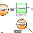
Phytoplankton & Carbon Cycling
Phytoplankton play an important role in the carbon cycle, by taking in atmospheric (inorganic) carbon and transforming in into organic
carbon that is consumed by zooplankton, grazers and other higher trophic levels. The eventual fate of this carbon, however, is determined
by which path this carbon takes, and can also be returned to the ocean and atmosphere. This pair of maps bring out the major players
in these cycles, including phytoplankton and bacteria.
Sergio Sanudo-Wilhelmy | USC Workshop
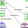
Storage of CO2 in Soils & Sediment
There's a lot that needs to happen in between the atmosphere and deep ocean sediments to allow carbon to be stored there for long time
scales. The scientist's concept map focuses on the role of plants to transfer the carbon into organic forms, and sink to the sediment
floor, creating ocean sediments that store carbon for long periods of time. The consensus map moves to the terrestrial environment, and
illustrates how plants create new sediments from the carbon that they take in ... [more]
Lawrence Mayer | DMC Workshop Topic: Marine Biology and Ecosystems
(Click images to view and save maps)
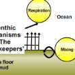
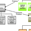
Benthic Organisms' Roles & Responses to Change
Benthic organisms live on the bottom of the ocean, most of which is composed of muddy substrates. Benthic organisms
include clams, scallops, sea stars, hermit crabs, worms, sea slugs, and sponges, and they both affect and are affected
by their environments. The original map is a model that shows various abiotic and biotic "inputs" that would affect
species abundance - including the amount of light, temperature, predators, and availability of food. The second map takes
a more illustrative view, highlighting the processes of deposition, respiration, mixing and burial that occur at the sea
floor, with benthic organisms acting as "gatekeepers" of carbon storage ... [more]
Peter Jumars | DMC Workshop
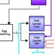
How Change Affects Marine Food Webs
In order to thrive, marine organisms have evolved strategies that maximize their chances of success in survival and
reproduction. For some fish, timing of the hatching larvae is controlled genetically, and evolved to match up with an
anticipated abundance of food (zooplankton) that results from spring blooms of phytoplankton. However, when the time of that
seasonal cycle is shifted - i.e., by an increased warming or changes in other factors that initiate a bloom - the larvae
may miss out on their main food source. The maps examine the long term and short term consequences of this mismatch, and how
climate change may affect fisheries as a result ... [more]
David Fields | DMC Workshop
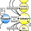
Humans and Estuaries
Estuaries are an important habitat for many organisms, functioning as nurseries for many species of fish, nesting areas for
birds, and protection for inland areas. While humans benefit from many of these services, they also take actions that
directly and indirectly affect the functioning of estuarine environments. The effects of water diversion, agriculture and
urbanization on estuaries are explored in these maps. In the consensus map, what can be done to change human behavior is
addressed.
Peggy Fong | USC Workshop
Importance of Bioluminescence
The ability for organisms to produce their own light using chemicals (known as bioluminescence) is found in many marine
organisms, and has evolved differently in different habitats. By studying the varied methods used to create light, and the
different ways in which these organisms use light (to lure prey, for countershading, etc.) - the focus of the first
map - researchers can learn how to use their understanding of light production to enhance human technologies (such as
materials sciences, genetic research and ecotoxicology) - which are identified in the second map.
Dimitri Deheyn | Scripps Workshop
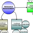
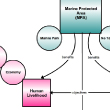
Marine Protected Areas
Managing marine resources involves a combination of traditional environmental policies and fisheries management. Another
tool in the arsenal of those attempting to preserve marine ecosystems is to create a Marine Protected Area (MPA). This pair
of maps outline the types of marine protected areas, and the costs, benefits and challenges of using an MPA as part of an
integrated conservation strategy.
Brad Erisman | Scripps Workshop
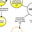
Microbes and the Ocean
Most people think of microbes as harmful "germs" that infect humans, viewing them in a negative light. However, though some
microbes are harmful, most are beneficial. In the ocean, they act as decomposers, breaking down waste, and also play
roles in generating nutrients for other organisms to use. With an emphasis on the ocean, the various roles of these
microbes are explored in this pair of concept maps.
Jed Fuhrman | USC Workshop
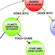
Role of Marine Biology in Atmospheric CO2
In the ocean, primary producers such as phytoplankton and cyanobacteria are responsible for the intake of carbon dioxide and
other nutrients. These primary producers are usually, in turn, eaten by consumers, which can range in size. The dynamic
between producers and consumers, and their eventual transformation into detritus, shape the ocean's carbon and nutrient cycles.
Lihini Aluwihare | Scripps Workshop
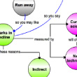
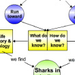
Shark Conservation
Direct fisheries for sharks, bycatch, and changes to shark habitats and prey have lead to worldwide declines in the
numbers of sharks, and yet, the cry for conservation may not be heard due to the negative reputations sharks hold. However,
with new technology giving a clearer picture of the mysterious lives of sharks, as well as better public education, there
is a potential to find new ways to protect these species.
Chris Lowe | USC Workshop Topic: Technology and Modeling
(Click images to view and save maps)
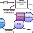
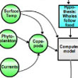
Right Whale Movement in the Gulf of Maine
Computer and mathematical models help researchers learn more about many ecological processes, but they can also
be used to calculate the likely location of some of the earth's rare whales - the North Atlantic Right Whale. Calculating
where whales are likely to be found in the Gulf of Maine takes data from a variety of sources - including information
about phytoplankton and ocean currents. Then, these outputs are tested, and the results are fed back into the model - helping
to constantly improve its accuracy ... [more]
Andrew Pershing | DMC Workshop
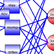
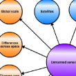
Ocean Technology & Exploration
As new autonomous and remotely operated vehicles continue to be developed for ocean research, choosing the right tool(s) to
address a particular sampling need is becoming more important. Each method has strengths, weaknesses, and a set of onboard
instruments to measure oceanographic data. The consensus map - which should be explored by turning its colored sections on
and off in the viewer - illustrates the relative capabilities of these instruments very clearly.
Oscar Schofield | Rutgers Workshop
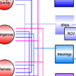
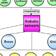
Sensing the Ocean Carbon Cycle
Studying the ocean can be a costly endeavor in time, personnel and money when using only ship-board measurements. However,
new unmanned sensors have the advantage of being able to be deployed and left for long periods of time, combined with
other data, all without needing to stop because they are tired. Drifters, buoys, satellites and gliders can assist ocean
scientists by increasing the time and spatial scale of their studies, and gather data to increase our understanding of
ocean processes ... [more]
Benjamin Twining | DMC Workshop |
||||||||||||||||||||||||||||||||||||||||||||||||||||||||||||||||||||||||||||||||||||||||||||||||||||||||||||||||||||||||||||||||||||||||||||||||||||||||||||||||||||||||||||||||||||||||||||||||||||||||||||||||||||||||||||||||||||||||||||||||||||||


|
|||||||||||||||||


