|
What Are the Climate Change Responses in the Arabian Sea? |
|
|
About Concept Mapping:
Concept maps are graphical tools that highlight fundamental concepts and the types of connections between concepts
within complex systems. Educators can use concept maps to assess how students develop understanding. For example, students
and educators can modify maps to reflect changes in the scope and depth of their understanding. The concept map on this page
was created using the COSEE-OS
Concept Map Builder.
About this Student:
Carrie Armbrecht is a graduate student in the School of Marine Sciences at the University of Maine. She is working towards
dual masters in Oceanography and Marine Policy (with a focus in education and outreach). She has a B.A. in Psychology from
Wellesley College. Her integrated thesis work with Dr. Fei Chai and Annette deCharon examines climate change in the Arabian
Sea region. She is looking at atmospheric and oceanic processes; social responses; and communication and education techniques
related to climate change.
[more]
|
|
To communicate science effectively there are challenges scientists should consider when trying to craft audience-appropriate
messages. The use of concept maps, people as facilitators, and effective teaching strategies can help scientists
communicate effectively. Challanges in Communication include:
|
1) | Packaging the message. |
|
2) | Complexity and uncertainty of content. |
|
3) | Understanding and engaging with the message. |
|
4) | Nature of the learner. |
|
5) | Transferring the message. |
|
6) | Nature of the specialist. |
ConnectionsConcept mapping allows both specialists and learners to see connections among related concepts. It shows the big picture,
while also allowing one to focus in on details. When a learner makes connections between concepts, her/his understanding
of the material deepens (deCharon, et al., 2009).
Take Home Message
Using concept maps is a skill that helps create a common ground for effective science communication.
Results from the case study below will be integrated into recommendations for effectively teaching climate change material.
|
|
Use of Concept Maps to Enhance Communication - A Case Study
This study looks at challenges which can occur during message packaging and understanding. Specifically it focuses on the use
of concept maps as an effective tool for creating audience-appropriate packages
( Figure 1).
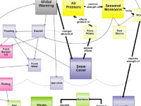
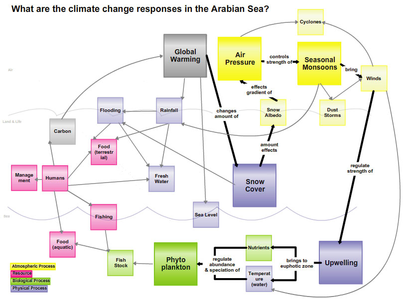
Using climate change responses in the Arabian Sea as an example ( Figure 2), we utilize concept mapping to clarify the
complexity of the story by attaching supporting resources (images, videos, articles, etc.) to our map
( Figure 3).
We will present the concept maps to high school, college, and web-based audiences. Levels of structure and order
of the presentation will vary, and the audiences will evaluate the concept maps and presentations for effectiveness.
|
|
|
)


)
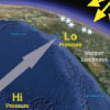
 causes an increased air pressure gradient (yellow). This gradient leads to stronger summer monsoonal winds (grey arrows). As a result upwelling (blue arrows) is stronger and there is more phytoplankton (green).','Figure 2'))
 lowers snow cover in the Himalayas (blue), and<br />causes an increased air pressure gradient (yellow). This gradient leads to<br />stronger summer monsoonal winds (yellow). As a result upwelling (blue)<br />is stronger and there is more phytoplankton (green).','Figure 3'))