 |
|
|
| SEARCH | WORKSHOP EVALUATION | |||||||||||||||||||||||||||||||||||||||||||
|
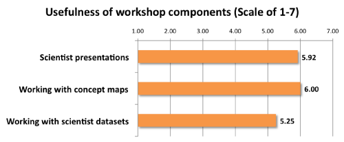
The quantitative and qualitative information COSEE-OS receives through each of its workshop evaluations is extremely important to our work. Each successive workshop evolves in response to the feedback we receive from participants. This pilot Curriculum Development Workshop, conceived in response to feedback from partner school districts, tested several different models for incorporating real data from scientists into classroom presentations and activities. A total of 17 educators from Maine, New Hampshire and Massachusetts participated in the workshop, and were comprised of high school, middle school and secondary (community college) educators. Concept Mapping Working with scientists on collaborative concept maps and listening to scientist presentations were highly rated portions of the workshop, with each getting an average rating of 6 out of 7 on a likert scale. "Working with scientist datasets" was rated as a 5.25 out of 7, on average.
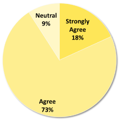
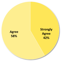
Concept mapping was shown to be a useful tool for translating science into the classroom. 80% of educator participants thought that concept mapping was helpful to them as away to share ideas and build a bridge of communication with the scientists. 83% of participants plan to use the concept maps created in the workshop, and 67% plan to use the subject matter and datasets from the workshop. Workshop Ocean Science Content The content featured in the workshop was broad and spanned many ocean and environmental science topics. Participants reported that the content would be useful in their teaching.
Quotes from Workshop Participants "I want to spread the news of the power of the concept mapping." "I'll be working more with concept maps for each unit. I haven't decided how just yet but eventually I would like students to be able to create study guides on their own with con dence." "I plan to use ocean examples to teach basic concepts." "I will include more ocean science in biology lessons and maybe extend watershed investigations to estuaries." "Great e ort on all of your parts to allow for depth of content, data and activities." "I am very excited to implement the software and to be able to have students save their maps and I can access them when they wish." "Great tool that will connect with students and scientists that are generating all this important data through which we can begin to make sense of all the changes that are currently occurring in the ocean." |
|||||||||||||||||||||||||||||||||||||||||||
|
|||||||||||||||||


