|
|
| SEARCH | NASA/JPL - 2015 | |||||||||||||||||||||||||||||||||||||||||||||||||||||||||||||||||||||||
|
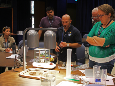
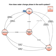
The goal of the Climate Connections workshop was to provide teachers with information from current earth science missions, along with an opportunity to learn hands-on activities and gather resources to pass along information to the students. The workshop's content was chosen to help educator audiences understand real-world applications in all parts of STEM (science, technology, engineering and math). Thirty three primarily middle and high school educators attended this workshop. On the first day, the participants heard from Aquarius, AirMOSS, GRACE, and Jason-3 mission specialists about current research efforts through a series of concept map presentations. The educators then had the opportunity to speak with each of the presenters over lunch to ask questions about the content of their research or to get a better understanding of their science. On Day 2, the educators engaged in a set of hands-on activities (see "Resources" below), and created a "Personal Plan of Action" to help bring newly learned content into their own classrooms. Featured Scientists and Engineers
Xueyang (Jessie) Duan
Jessie Duan is a postdoctoral research associate in the department of Electrical Engineering in the University of Southern California, working on the AirMOSS project.University of Southern California
Mark Fujishin
Mark Fujishin manages JPL's Earth Science Missions office. He oversees operations for earth science instrument and satellite projects, along with the on-site Earth Science Mission Center facility.NASA JPL
Alex Gardner
Alex Gardner is a Research Scientist in the Solid Earth Group, in the Earth Sciences Section. He studies the Earth's cryosphere (frozen Earth) with a particular focus on glaciers and their impacts on sea level rise and water resources.NASA JPL
Tony Lee
Tony Lee is the Project Scientist for the Aquarius/SAC-D Satellite mission. His research interests include ocean circulation and its relation to climate variability on seasonal-to-decadal time scales.NASA JPL
J.T. Reager
J.T. Reager is a research scientist in the JPL Water and Carbon Cycles Group. He uses GRACE observations of water movement to study flood and drought occurrences and to measure the strength of the global water cycle.NASA JPL
Alireza Tabatabaeenejad
Alireza Tabatabaeenejad is a Research Assistant Professor in the University of Southern California's Department of Electrical Engineering – Electrophysics. He is the Lead Investigator on the AirMOSS Root-Zone Soil Moisture Retrieval Algorithm Team.University of Southern California
Jorge Vázquez
Jorge Vázquez is the NASA Physical Oceanography Distributed Active Archive Center (PO.DAAC) scientist for sea surface temperature (SST) and sea surface salinity. He also serves as the chair of the Applications and User Services Technical Advisory Group for high-resolution SST.NASA JPL
Victor Zlotnicki
Victor Zlotnicki is the Assistant Section Manager of JPL's Earth Science Section. His research interests include separation of geophysical from ocean circulation signals in satellite altimetry and GRACE data.NASA JPL Learn more about NASA Aquarius at http://aquarius.nasa.gov. Resources
Sea Level Rise. The student will perform an experiment to learn that melting land-based ice contributes to greater sea-level rise
than melting seal. Instructions (PDF, 500 KB)Altimeter in a Box. Students will explore how satellite altimeters work by constructing and mapping “ocean topography” in a closed box. Instructions (PDF, 1.4 MB) Effects of Temperature & Salinity on Density & Stratification. This activity compares salt and fresh water, demonstrating that fluids arrange into layers according to their densities. Instructions (PDF, 577 KB) Oceanic Adventure - Voyage on the High Seas. This game is suitable for play both within and outside of the classroom. On the reverse, there are black and white educational activities designed to be reproduced directly from the poster for use in the classroom. Online Game SMAP Block Pattern Soil Moisture Protocol & Activity Sheet. Hands-on activity in which students collect a soil moisture sample of the top 5 cm of soil for comparison with Soil Moisture Active Passive (SMAP) satellite observations. Instructions (PDF, 229 KB) | Data Sheet (PDF, 107 KB)
|
|||||||||||||||||||||||||||||||||||||||||||||||||||||||||||||||||||||||


|
|||||||||||||||||


