SEARCH MODELING OCEAN CLIMATE SYSTEM
WORKSHOPS
 
Scientist-Educator Collaborative Workshop
Modeling Ocean-Climate System: The Myth of the Single Model
Held at the New England Center on the University of New Hampshire Campus
Friday, March 13, 2009 through Saturday, March 14, 2009
EVOLUTION OF THE CONCEPT MAP
Click Images to Enlarge
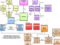
Original concept map created by Carolyn Jordon
Digital concept map created in the COSEE Concept Map Builder
Consensus concept map created using the COSEE-OS Concept Map Builder
Click Buttons for
Presentation Videos & Maps

About this Workshop:
For this workshop, 12 educators from the New England area were matched with ocean and climate scientists from the University of New Hampshire to improve their collective understanding of Earth's major ocean - climate systems. [more]

About this Scientist:
Carolyn Jordan studies the chemical transformation and growth of aerosols in the atmosphere as they relate to climate change. These aerosols may be natural such as marine sea salt particles or dust, or they may derive from human made sources. [more]
Click Images to Learn More About the Educators
Who Worked on this Concept Map
 
 
Chet Orban
Stephen Sousa
 
 
Carolyn Jordan
 
Scientist Carolyn Jordan explains the concept map and its development:

Many students ask: "What is a model?" It is a mechanism we use to understand chemistry, physics, and biology through mathematical representations of the real world. These are used the simulate nature and understand it better. To build a good model, the first question is: What is your purpose? For example, you can have an "operational" model that is well established and reliable. National Weather Service models are good examples. A "research" model, on the other hand, is often created to make operational models even better.

The next question is "What process am I trying to simulate?" For example, for weather you may want to predict rainfall, fog, etc. For chemistry, you may want to look at trace gases, chemical transport, etc. For ocean sciences, you may want to understand how ocean circulation works. This "process" questions feeds into spatial scale: Is it a global model? A regional model? Or even something that occurs on molecular scales. This is one reason why there is no "one size fits all" model... there is not enough computational power to cover all scales at once. That's also why different models often have different results: most modelers emphasize their own area of interest (e.g., the data they are most familiar with and the scale at which that data is most relevant).

Time (or "temporal scale") is extremely important, especially when it comes to climate change models. What were climate conditions in the past? How do they compare to now? What has caused the changes to occur? And, importantly, what are the trends for future climate? We need to look at various models at many different scales to collectively understand what our future climate may be like.
View All Concept Maps Created at this Workshop
Concept map