Scientist-Educator Collaborative Workshop
Workshop Evaluation: Concept Mapping |
|
Held at the Seacoast Science Center in Rye New Hampshire
Monday, June 1, 2009 through Wednesday, June 3, 2009 |
|
|
|
Concept maps are designed to help teachers and their students understand connections and complex relationships. At COSEE-OS workshops, this
tool is used to build understanding about climate and oceanography content. For scientists, concept mapping helps them share their understanding
of connections in the earth system. For educators, concept maps can be powerful tools for exposing and clarifying topics in the classroom. For
more information about concept mapping, visit this page.
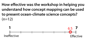
The feedback about concept mapping from the informal educators has been very positive. In their post-workshop evaluations, when educators
were asked, "Do you think the process of concept mapping helped you think through the topics you learned during this workshop?" 92% of them
said "yes" (n=15). 83% of participants also responded in the affirmative when asked if concept mapping was a helpful way to "share ideas and
build a bridge for communication with scientists." Educator responses also showed that they considered concept mapping to be an effective
tool in helping them to present ocean-climate science topics, as shown on the scale above.
|
|
|
Watch a video
of visiting researcher Jeff Beaudry discussing the reasons that concept mapping is a good tool for scientists. |
Quotes from Workshop Participants
"I like it better now that I am not using [concept mapping] as an "assessment" tool and more of a learning/thinking tool."
|