Scientist-Educator Collaborative Workshop
Workshop Concept Maps |
|
Held at the Darling Marine Center in Walpole, ME
Friday, November 22, 2008 through Saturday, November 23, 2008 |
|
|
|
|
|
| View all workshop concept maps |
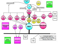
Concept maps are designed to help teachers and their students understand the connections and relationships between climate and
oceanography by using a visual means of communication. Concepts are linked visually, which contributes to a more comprehensive understanding
of a complex scientific idea. For scientists, concept mapping helps them share their understanding of connections in the earth system, and put
their research into the context of a "big picture". For educators, concept maps can be powerful tools for exposing and clarifying topics
in the classroom.
This workshop consisted of five teams of formal educators and scientists (1 scientist:3 educators ratio) who created online
learning resources that align with National Science Education Standards, Climate Literacy Principles, and Ocean Literacy Principles.
Topics focused on the current research topics of the internationally known scientists who participated in the workshop, and each team
created a series of concept maps consisting of the following:
- An original concept map created on paper by the scientists on day one of the workshop
- A digital concept map created in the COSEE Concept Map Builder and presented to educators on day two of the workshop
- A consensus concept map created collaboratively between scientists and educators using the COSEE-OS Concept Map Builder
Topics were:
Each team's concept maps are described on pages accessed from the menu at left, or click here to view and/or download all digital
maps created at this workshop.
|