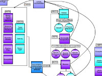
Scientist Kari Heinonen explains the concept map and its development:
I research invasive species that are transported from their ecosystem of origin to
another "recipient" ecosystem by either biologically or human-mediated means (e.g., marine animals, human introduction,
ship ballast water) and/or by physical forces (e.g., currents, winds). My original two maps were designed to answer
these questions about invasive species: What factors contribute to a successful invasion? What are the impacts of such
invasions?
On my "To Educators" map, the box at left shows a number of factors that determine whether or not the invasive
species will become established in its new ecosystem and start a reproducing population. These factors can be divided
into two categories: biotic factors (e.g., competition from other organisms, available food/prey) and abiotic factors
(e.g., temperature, salinity). Potential post-colonization impacts of invasive species to humans, ecosystem community
composition, and habitat is outlined in the right half of my map. These impacts are also separated into biotic (purple)
and abiotic (teal) categories.
If we examine human-related impacts, invasive species can have both direct and indirect effects. For example, public
health can be affected directly if invasive species are vectors for new disease or new parasites (e.g., Chinese mitten
crab can be the host for the Oriental lung fluke that is able to parasitize humans). Our economy can be impacted
indirectly if an invasive species out-competes or preys upon a commercially viable species in a fishery. Other biotic
impacts include influences on the new ecosystem's community composition through food web interactions and competition
pressures. These pressures, in turn, can cause other species' populations to either decline (sometimes to extinction)
or increase. Invasive species can also lead to habitat degradation: for example directly through manipulation of
habitat substrate (e.g., bioturbation of the sediments). Impacts can also be caused indirectly via growth of the
organisms themselves (e.g., invasive algae may be able to grow faster than native species and monopolize space, light,
and nutrients).
Working with educators helped me create a more easily understandable map by adding the words "factors", "impacts",
"abiotic", and "biotic" to classify the different sections. We also added a color-coded legend to help readers sort
the concepts into major categories: ecosystem, abiotic factors, biotic factors, mitigation, and invasive population.
We felt that these seemingly small changes drastically improved the "flow" of the map - especially for users new to
the topics. Also, two new concepts were added under the category of "Mitigation" ("Risk Assessment" and "Best
Management Practices") to enable teachers and students to bring this story full-circle and discuss the types of
actions communities are implementing to deal with invasive species. Educators also liked that this collaborative
map was general and flexible enough to be utilized with nearly any invasive species exploration. For example,
students could be assigned an invasive species to explore. Using the "Group Final Map" as a guide, they could
research the factors that led to successful colonization, potential or real impacts of the species on their
new ecosystem, and potential mitigation strategies (already in place, or proposed).
|
 on the<br />first day of the educator-scientist collaborative workshop','Concept map'))
)
)