I'm a physical oceanographer and spend a lot of my time modeling the coastal waters. We look at river
plumes, how they connect the land to estuaries, and how they can even affect the open ocean. It's well known that river
plumes influence marine life, climate, and physical/chemical/geological dynamics, both close to the river and hundreds
of kilometers away.
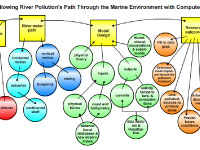
The concept map I presented to the educators focused on how we track river plumes with computer
models. The four main questions addressed are: "What's in a river plume?," "What happens to a river plume as it moves
through coastal waters?," "How do we make a model?," and "How do we use a model?" River plumes contain fresh and salt water,
pollutants, nutrients, plankton and sediments. Many things can influence a river plume as it travels along its path from
land, along the coast, and offshore. Various processes can affect the density / buoyancy of a river plume such as mixing
by tides, winds, waves. River plume computer models need a way to represent the physics of the river plume using equations;
these are based on scientific theory, experiments, and observations. Specific local models need to take into account the
forces that affect that plumes including tides, storms, etc. Since it's not possible to get data from everywhere in a
river plume, models can "fill in the gaps" of missing data. Models also help us to connect with other disciplines, for example
physical-biological models.
The map the educators and I collaborated on followed the same basic format I presented. However, we decided to reduce
the number of concept "circles" and focus on the example of pollutant transport to give students a clearer picture of
how river plumes can affect their daily lives. To illustrate, I shared an example of how the Delaware Bay river
plume was modeled to help answer questions about water quality issues downstream of this river plume.
(
Click for model output |
Click for presentation)
)
)