My field is circulation and mixing in the coastal oceans. When I first tried
to create a concept map, I realized that this field is relevant to so many things that it might be better
to give a specific example. So I chose a topic that I hoped people could engage with: circulation data
that are used for search and rescue purposes. I began my
presentation to educators
by comparing three methods that can be used to track where a person would travel over an 24-hour period if s/he
was being carried by ocean currents (link to video). One set of data were collected by an experimental float with
a GPS system. We compared these actual data with two computer models: one that has traditionally been
used by the Coast Guard and another that uses hourly CODAR (COastal raDAR) data. (Note that CODAR data are
now available throughout much of the eastern seaboard.)
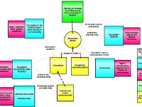
I constructed the map with the problem in the middle: "Where do we search?" and the pieces needed to find
the answer: last known position and time, instruments that provide data on circulation in the search area,
and a simulation model. From all these, we can forecast (or estimate) where to send the rescue helicopters.
Around this problem statement, I came up with some broad science concepts (in blue) and associated specific
topics (in magenta). For example, at upper left I addressed the descriptive statistics used to characterize
circulation: i.e., the broad concept of coastal ocean structure / variability and the specific topics of
variance, tides, etc. At lower left I included the basis of measurements such as radio waves and Doppler
effect. The right-hand side of this map focuses on three fundamental aspects of simulation models: automation
of forecasting systems, testing of models, and the mathematics behind the models. A point I wanted to emphasize
is that models are not "right" or "wrong": they are either
consistent or
inconsistent with actual
data. Like the
example
I showed, we weren't able to verify that the CODAR-based model was more consistent than the traditional
model until we compared it to the actual float experiment data. Moreover, to be truly useful for operations,
a model must provide robust data quickly in an automated way. In this scenario, the model output would
inform the helicopter pilots where to perform their search and rescue operations within a few hours.
In collaboration with the educators, we decided to keep the same basic structure as my "search and rescue"
concept map but changed the focus question to "How does the movement of water affect the movement of
organisms in Long Island Sound?" I found the conversations with the educators -- and the shift in topic
to better meet their needs -- quite informative and enlightening.
 on the<br />first day of the educator-scientist collaborative workshop','Concept map'))
)
)