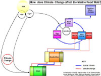
For this workshop, participants consisted of seventeen graduate and post-doctoral students working with five ocean science researchers from several institutions. Workshop groups (in a 3:1 student to faculty ratio) collaborated to develop concept maps using targeted focus questions based on ocean and climate literacy fundamental concepts. Through an iterative process involving web-based concept mapping and multimedia tools (Concept Map Builder and Ocean Climate Interactive), the teams developed "consensus" concept maps based on the researchers' initial focus questions and presented them to their peers for feedback. Next, the graduate students were tasked with presenting to a completely different audience - 15 high school students from Waterville Senior High School in Waterville, ME - to challenge them to apply their presentation skills to non-scientist audiences. This "third party" audience provided valuable insight for the presenters, as well as helping the researchers to see how their original messages were translated to an intended audience.
Scientists at this workshop explored a wide variety of topics in their concept maps including: the use of computer models to determine whale location patterns, the use of sensor technology to map what is unknown about the ocean, climate processes that affect the burial/sequestration of carbon in marine sediments, the role of benthic organisms in the carbon cycle, and the affect of climate change on marine food webs.
Workshop materials: Scientist's Agenda | Graduate Student's Agenda
LEARN MORE About Concepts Maps from this Workshop |
|
|
|||


